The coastal areas of islands in the Caribbean are subject to erosion and inundation due a number of causes, such as waves due to swell and hurricanes, storm surges, sea level rise, reef damage and human activity. Improving our understanding of ocean wave processes and energy dissipation along the islands coastline and surrounding waters is consequently essential for being able to assess the current and future risk of damage to both natural and man-made features, and is critical for making informed coastal management decisions.
To help facilitate this, this project has developed Caribbean-wide regional wave and hydrodynamic models that provide boundary conditions for high-resolution coastal water level, current and waves for local-scale beach modelling. Specifically the project has enhanced state-of-the-art ocean modelling frameworks such as NEMO (Nucleus for European Modelling of the Ocean) with region-specific adaptations and thermodynamic parameters, and has applied other specialist models and tools such as the LISFLOOD-FP rainfall runoff and inundation model, XBeach storm impact model and the SWAN wave model for local-scale modelling.
Whilst the enhancements made to Caribbean ocean modelling capabilities through this project benefit all countries within the region, many of the case studies conducted thus far have focused on St Vincent and the Grenadines due to the propensity of vulnerable infrastructure and settlements caused by the combined pressures of a shortage of low-lying land and an increase in coastal erosion on the eastern (windward) coast exposed to swell and storm waves from the North Atlantic. Multiple training and consultation workshops have also been conducted through the project, providing regional stakeholders with guidance on an array of ocean modelling software packages and tools used, and have been supported through a number of community-focussed events such as an exhibition on the theme of coastal resilience at Argyle International Airport in St Vincent in January 2019.
Outputs
- Development of a regional ocean model for the Caribbean that includes tides, lateral boundary forcing, realistic thermodynamics and baroclinic dynamics and atmospheric forcing.
- Development of a regional wave model for the Caribbean that includes atmospheric forcing.
- Generalised assessment of the wave climate and coastal flooding and erosion hazard exposure for the Caribbean region
- Implementation of a coastal wave model for the SE coast of St Vincent, focussing on a strip of reclaimed land in the vicinity of Argyle International Airport.
- Flood risk assessment for Argyle International Airport during storm events under different seal level rise scenarios.
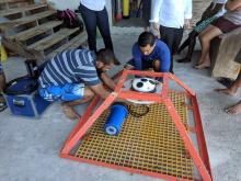
- Provision of an acoustic wave and current (AWAC) gauge and training of local personnel in deployment and data interpretation.
- Acquisition of in situ data on water level, currents and waves in the nearshore zone off the east coast of St Vincent where coastal erosion/retreat is being observed during both the hurricane (wet) and winter (dry) season.
- Modelling of changes in beach profile at Black Point Beach (one of the most popular heritage and recreational parks on the windward coast of St Vincent) using a storm impact model.
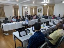
- Three training workshops held in St Vincent and the Grenadines and Grenada.
- Development of software for tide gauge quality control and analysis
- Development of a pilot data portal for sharing data and software
Workshops
- Advanced Scientific Techniques to Inform Integrated Coastal Zone Management (March 2021; Online). Multi-disciplinary workshop on the governance or management of the coastal zone. The principal themes were in situ sensor-based monitoring, habitat mapping via geo spatial modelling and remote sensing, and hydrodynamic modelling to determine coastal zone functioning and hazard assessment. The workshop concluded with a knowledge exchange exercise aimed at identifying scientific evidence needs to support policy development. https://noc-events.co.uk/conference/virtual-workshop-cmep-advanced-scientific-techniques-inform-integrated-coastal-zone
- Stakeholder consultation on Coastal Monitoring and Modelling for Small Island Developing States (November 2020; Online). https://www.cmeprogramme.org/sites/cme-programme/files/documents/Caribbean%20workshop%20Summary%20Report.pdf
- Monitoring and Modelling for Coastal Zone Management (March 2020; St Vincent and the Grenadines). Presentation and handover of the outputs of local case studies investigations to agencies responsible for managing the coastal and marine environments, and provision of more focussed modelling/technical support in response to specific feedback and requests. https://www.youtube.com/watch?v=GEqOXRKtqTc&list=PLoYJVOchmO7F9eb_75NozU6znP5ze7RIb
- Monitoring and Modelling for Coastal Zone Management (January 2019; St Vincent and the Grenadines; Grenada). Technical support and guidance on the software packages and modelling tools being used.
- Monitoring and Modelling for Coastal Zone Management (March 2018; St Vincent and the Grenadines). Training provided on satellite oceanography, wave modelling and shoreline management.
Publications and reports
- Quantifying processes contributing to marine hazards to inform coastal climate resilience assessments, demonstrated for the Caribbean Sea. S. Jevrejeva, L. Bricheno, J. Brown, D. Byrne, M. De Dominicis, A. Matthews, S. Rynders, H. Palamisaly and J. Wolf (2020). Natural Hazards and Earth System Sciences, 20, 2609–2626, doi: 10.5194/nhess-20-2609-2020
- Guidance Note on the Application of Coastal Monitoring for Small Island Developing States. A. Becker, L. Bricheno, J. Brown and J. Wolf (2020). NOC R&C Report #74.
- Development of a regional ocean model for the Caribbean, including 3D dynamics, thermodynamics and full surface flux forcing. C. Wilson, J. Harle and S. Wakelin (2019). NOC R&C Report #65.
- Current and future vulnerability of Argyle International Airport to combined river and coastal flooding. B.T. Philips, J.M. Brown, A.E. Becker and A.J. Plater (2019). NOC R&C Report #68.
- Deployment of an AWAC off the East coast of St Vincent, 2018-19. J. Wolf, G. Williams and J. Ayliffe (2019). NOC R&C Report #69.
- St Vincent – Black Point Beach Modelling. T. Prime, J. Brown and J. Wolf (2019). NOC R&C Report #70.
- Guidance Note on the Application of Coastal Modelling for Small Island Developing States. J. Wolf, A. Becker, L. Bricheno, J. Brown, D. Byrne, M. De Dominicis and B. Phillips (2020). NOC R&C Report #73.